T Home Virtual Navigation Recce.
Many of you reading the Face book posts will be frustrated by having no opportunity to Recce the course . You have probably studied the Maps and perhaps read Damian Hall's guide book to the PW.
You can take your research further scrolling through Google Maps Satellite Images
This should be undertaken systematically with your maps open next to the computer.
Look at a section on the map then follow on with Google. Your primary motivation is to get familiar with the map rout . The satellite images are just a bonus amount of information.
It is hard work and sometimes difficult to reconcile the satellite images with the map .
The other thing you should try is tracing your map rout with the Images shown on your GPS. This is even harder work so again take your time and take plenty of breaks.
Spend a long time comparing images from Map ,Google, And GPS base map of the same points on the course and the information will sink in better.
Pay particular attention to the deviations from the PW trail leading in and out of each CP and areas where you will need to apply MICRO NAVIGATION.
Spine Micro Navigation
I define this as working your way through small areas packed with complex features .
These are often villages and towns where there are few if any PW markers . Village roads buildings and driveways can be very confusing .

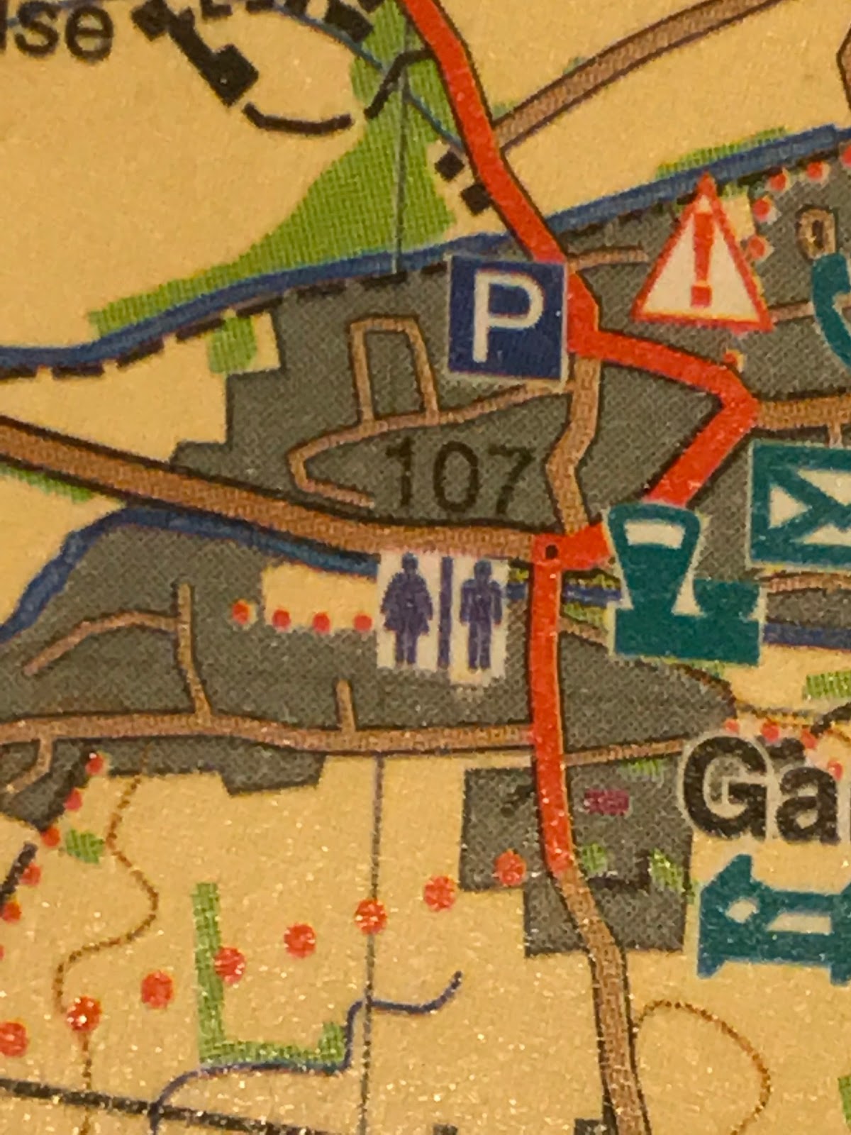
This is How Gargrave is shown on the Harveys Pennine Way Map . The image has been blown up for clarity and if you have really good eyesight you might conclude when looking at this image on your actual map that there are very few streets in Gargrave . Google Satellite image will show you that this is far from true! There are hardly any PW signs , no friendly footpath to follow and plenty of turnings to overshoot.

1:25,000 image shown on the AZ Map gives more detail but still net easy to decipher.
These are often villages and towns where there are few if any PW markers . Village roads buildings and driveways can be very confusing .
This is How Gargrave is shown on the Harveys Pennine Way Map . The image has been blown up for clarity and if you have really good eyesight you might conclude when looking at this image on your actual map that there are very few streets in Gargrave . Google Satellite image will show you that this is far from true! There are hardly any PW signs , no friendly footpath to follow and plenty of turnings to overshoot.

1:25,000 image shown on the AZ Map gives more detail but still net easy to decipher.
Farms will always cause you problems . The closer you get to farm buildings the more any sign of the trail gets obliterated by multiple animal tracks . You will encounter multiple gates close together with small paddocks . The farm buildings do not always look like what is shown on the map . Just to add to your problems as you approach a farm at night you will usually hear dogs (Your imagination will visualise them as massive beasts with the blood of a previously mauled Spine Racers still dripping from their lips) . In reality most farm dogs are tied up . At night farmers have developed the mean trick of blinding you with PIR security lights so you blunder into the electric fence!
To sum up if undertaking a real or virtual Recce take your time studying the farms you will encounter . Especially the image shown on your GPS mapping.
All this Computer activity will only give you an overview.
There is one area where the Virtual Recce can be incredibly effective in slashing time required to nav during the race.
During the race at times you will suffer from the effects on Navigation Transition.
Your normal stressed Spine Racer Response will be to pause and look around for any clues . The next thing you do is look at the map or GPS (All this time you are probably halted).
Your brain has to adapt to a new way of working.
Navigating through built up areas is all stop start and hesitation unless you have done a recce.
As with most things Spine the effect is far worse at night . Streetlights tend to make things worse and as for street signs you want one with the words Pennine Way not Fuck..ng Settle or Skipton!
For the bits where the PW passes through towns this is MAGIC.
To appreciate just how good this is try the following exercise . If you run through this a few times you will save a minimum of 5mins and possibly treble that if it is really dark and miserable
1 Enter Gargrave in google maps and compare the satellite overview with your map. you need to know the rout through the streets plus the all important location of the CO-OP .
2 Starting from the bridge into town switch to street view and tap tap tap with the arrows over the bridge turning right on High Street until you find the CO-OP.
3 Rotate and take a look at the shop front ( YOU SHOULD BE ABLE TO SMELL THE HOT PIES INSIDE!)
4 Retrace path from co op back to the bridge.
5 Turn north and following West Street and nav your way through the town.
6 Look out for the turn in to Mark House Lane and cross the small second bridge.
7 The street view images stop a short way along Mark House Lane but you have navigated your way through town .
Repeat the exercise noting what the street signs look like and on what side of the roads they are located.
NAV TRAP -- SD 924 550 the PW branches off right above Mark house lane (it's easy to miss the turn)
Once you have convinced yourself how useful this method is , go back to your maps and repeat at every village you pass through .
Do This With : The White House Junction
The CP1 turn off at SLACK
Cowling
Thornton In Craven
Lothersdale
Gargrave including the Co op
Malham
Horton In Ribblesdale
Haws ( including the pie shops)
My guess you will cut 30+ mins off your finish time at Haws
FOR THE FULL SPINE: Hardrew
Thwaite
Tan Hill ( where its easy to overshoot the bit after the pub)
Middleton (all the way to the CP and back including the shops. )
Dufton including the Village Hall CP)
Gargill (inc the bit where the path rejoins the river )
Alston bridge crossing (+diversion heading up road to The Spar Supermarket next to the texaco garage)
A69 crossing inc diversion to Greenhead pub and Cafe
The Roman Army Museum Car park (it's confusing)
Bellingham CP and town (Another Co Op to Locate)
Byrness CP and the path back to the trail
KIRK YETHOLM
DON"T CHECKOUT ALL THE ABOVE IN ONE MASSIVE SESSION .
THE OBJECT OF THE EXERCISE IS TO IMPRINT CLEAR MEMORIES ON YOUR BRAIN
By now you should be bog eyed but have memory rout triggers lodged in your brain.
Street view is not perfect it all takes some effort working out which way to turn BUT this is exactly how difficult it will feel during the actual race .
If you think this is hard then try the same thing with your MAPS!
Study Gargrave on your maps . It is hard to make sense of the rout.
Harveys shows very little detail and even on the AZ 1:25000map you may need a magnifying glass.
Every town and village will cost you extra time hesitating to constantly cross check your maps and GPS.
Before you quit the exercise it's worth looking at the images of Gargrave displayed on your own GPS . It is probably 1:50000 scale and you need to zoom right in to get the street detail. Unfortunately as you do this the Pennine way red diamonds become few and far between so it's difficult to work out which roads the PW follow.
The Image below is the image shown my GPS screen showing Gargrave. The thin red line is a rough track I made before the race using Garmin Basecamp. (Note i made an error entering this line , on the lead into town cutting a corner by following a road)
 Spine Issues GPX waypoints (purple line)are even more alarming there are only two waypoints!!
in My version (2015 edition GPX) all they give you is a 1km long straight line across the rooftops of Gargrave This is illustrates why you cannot rely just on the GPX files
All this Computer activity will only give you an overview.
There is one area where the Virtual Recce can be incredibly effective in slashing time required to nav during the race.
During the race at times you will suffer from the effects on Navigation Transition.
Navigation Transition
This occurs when you rapidly change terrain . Out on the Footpaths and Fells you will fall into the groove of navigating to the best of your ability.
As soon as you enter a Town or village all the normal Nav Clues such as footprint trails , Finger Posts and the little Pennine Way Markers Disappear.Your normal stressed Spine Racer Response will be to pause and look around for any clues . The next thing you do is look at the map or GPS (All this time you are probably halted).
Your brain has to adapt to a new way of working.
Navigating through built up areas is all stop start and hesitation unless you have done a recce.
As with most things Spine the effect is far worse at night . Streetlights tend to make things worse and as for street signs you want one with the words Pennine Way not Fuck..ng Settle or Skipton!
All is not lost as I give You :
GOOGLE STREET VIEW
For the bits where the PW passes through towns this is MAGIC.
To appreciate just how good this is try the following exercise . If you run through this a few times you will save a minimum of 5mins and possibly treble that if it is really dark and miserable
Virtual Exercise
1 Enter Gargrave in google maps and compare the satellite overview with your map. you need to know the rout through the streets plus the all important location of the CO-OP .
2 Starting from the bridge into town switch to street view and tap tap tap with the arrows over the bridge turning right on High Street until you find the CO-OP.
3 Rotate and take a look at the shop front ( YOU SHOULD BE ABLE TO SMELL THE HOT PIES INSIDE!)
4 Retrace path from co op back to the bridge.
5 Turn north and following West Street and nav your way through the town.
6 Look out for the turn in to Mark House Lane and cross the small second bridge.
7 The street view images stop a short way along Mark House Lane but you have navigated your way through town .
Repeat the exercise noting what the street signs look like and on what side of the roads they are located.
NAV TRAP -- SD 924 550 the PW branches off right above Mark house lane (it's easy to miss the turn)
Once you have convinced yourself how useful this method is , go back to your maps and repeat at every village you pass through .
Do This With : The White House Junction
The CP1 turn off at SLACK
Cowling
Thornton In Craven
Lothersdale
Gargrave including the Co op
Malham
Horton In Ribblesdale
Haws ( including the pie shops)
My guess you will cut 30+ mins off your finish time at Haws
FOR THE FULL SPINE: Hardrew
Thwaite
Tan Hill ( where its easy to overshoot the bit after the pub)
Middleton (all the way to the CP and back including the shops. )
Dufton including the Village Hall CP)
Gargill (inc the bit where the path rejoins the river )
Alston bridge crossing (+diversion heading up road to The Spar Supermarket next to the texaco garage)
A69 crossing inc diversion to Greenhead pub and Cafe
The Roman Army Museum Car park (it's confusing)
Bellingham CP and town (Another Co Op to Locate)
Byrness CP and the path back to the trail
KIRK YETHOLM
DON"T CHECKOUT ALL THE ABOVE IN ONE MASSIVE SESSION .
THE OBJECT OF THE EXERCISE IS TO IMPRINT CLEAR MEMORIES ON YOUR BRAIN
By now you should be bog eyed but have memory rout triggers lodged in your brain.
Add in all the effects of sleep deprivation and I suspect that STREETVIEW could cut one hour off your finish time!
Street view is not perfect it all takes some effort working out which way to turn BUT this is exactly how difficult it will feel during the actual race .
If you think this is hard then try the same thing with your MAPS!
Study Gargrave on your maps . It is hard to make sense of the rout.
Harveys shows very little detail and even on the AZ 1:25000map you may need a magnifying glass.
Every town and village will cost you extra time hesitating to constantly cross check your maps and GPS.
Before you quit the exercise it's worth looking at the images of Gargrave displayed on your own GPS . It is probably 1:50000 scale and you need to zoom right in to get the street detail. Unfortunately as you do this the Pennine way red diamonds become few and far between so it's difficult to work out which roads the PW follow.
The Image below is the image shown my GPS screen showing Gargrave. The thin red line is a rough track I made before the race using Garmin Basecamp. (Note i made an error entering this line , on the lead into town cutting a corner by following a road)

in My version (2015 edition GPX) all they give you is a 1km long straight line across the rooftops of Gargrave This is illustrates why you cannot rely just on the GPX files
Without a good basemap of at least 1:50,000 scale the GPX waypoints are near impossible to read.
One final bit of advice . It is possible to download detailed Pennine Way Track logs from blogs on the Long Distance Walking Association website. These are way more use than the primitive Spine Official GPX files which have been severely simplified to prevent them crashing low capacity cheep GPS units .
The one thing that non Spine GPS tracks will not show are the trail deviations to CP's not on the pennine way.
Good luck and don't stay up to late and Crash Google Maps!
PS I would love feedback from anyone applying the Streetview Exercise then going out on a real recce. It should help you speed through all the villages without the usual hesitation.
No comments:
Post a Comment