
Falling back on nav adds such as GPS and Maps will drastically slow your pace . We will normally avoid active navigation with aids unless we acknowledge just how dangerous a strategy "following can be".
You can test this by running with a partner of a similar pace . As soon as you get your map or GPS in your hand and glance down you will fall behind.
This is where your training should come in. YOU WILL PROBABLY HATE THIS ROUTINE!
To reduce speed lost you need to reduce the time your eyes are looking away from the trail. You can achieve this by having a map/GPS stowage system that you can access without looking. Once you have worked out how to do this you need to go out running with your gear ,and set up and a beep timer set to beep every 5 mins . On the beep get out the nav gear and look at it properly so you can see how your position on the trail relates to the info on the map/GPS . ( If you are passing a track junction find it on the map.
All this action will drastically slow you up but gradually you will get more efficient and loose less overall speed. There is also an important side effect in that regularly glancing at a GPS will become a habit so during the race it will feel like a natural action rather than an annoying inconvenience.
For a novice navigator getting to the point where you accept that active navigation will make you faster in the long term is a real mental barrier. This is the reason why fast runners often will try Orienteering then almost immediately give the sport up. Taking up Orienteering will teach any runner that a complex route can be completed faster by focusing on navigation rather than running .
Night time Spine Navigation will almost always be potentially complex.
When it comes to complex nav Ultras like the spine the orienteers have a massive advantage because they will spend far more time actively navigating.
Any Spine /Challenger novice running solo will probably loose at least one hour due to nav errors every 20 hrs. This puts trying to gain time by using ultra light kit as an insignificant factor.
What do we want from our GPS nav equipment?
The answer is a car type satnav type system .
The car satnav works with your brain in a different way to a hand held GPS.
1 It does not require you to hold it.
2 It is usually set up near your sight line to the road.
3 It will give you verbal prompts to any deviation from a straight line.
4 It will describe objects requiring radical changes in direction reducing the time your need to look at the screen and process the information.
5 It will stay quiet when no nav action is required from you.
Car Satnav designers take great care to minimise the amount of attention your brain needs to get to your destination. The device will only ask for you to take action if a direction deviation is required. . They also know about the straight line tendency.
The Walkers/Runners GPS unit.
This is a totally different beast. Most units take very little account of the mental effort required to use them. Some are made so complex that one slight slip on a menu page can require you to seek out the manual (Printed usefully in 16 languages!) . Most are designed to be used while stop ed and held steady. The watch style GPS units can be better but tend to monitor where you have been rather than where you are trying to get to.
It's not all bad and a GPS will probably at some point save your race BUT ONLY IF YOU KNOW HOW TO USE IT.
If you are buying a GPS you need one with an adequate base map. As a minimum I would recommend OS 1:50,000 mapping.
You need to set the unit up so your direction of travel is towards the top of the screen and the map scrolls down as you move forward. The reason for this is that you need be able hold the screen up in front of you and let your eyes look up and see the actual terrain without asking your brain to swivel the view to account for where north is .
If possible get OS 1:25000 mapping. You may think that this is the same as a zoomed 1:50,000 map but there is much more information on the 1:25000 maps including most of the crucial wire fence boundaries on the low level farmland. If you try to Zoom right in on the 1:50000 base map you will discover that the red diamond pennine way cymbals are so large that you can't discern their direction.
You also need to know how to easily access the OS Grid ref from your GPS. This is a safety precaution that will allow the Spine Rescue teams or MRT to accurately locate you if you need to call for help. The Trackers attached to your pack work on the phone signals (if there is one ) and will give your rescuers insufficient information to reliably find you fast. In the past having the Grid ref permanently displayed on your home screen has been recommended but in practise you need that screen as un cluttered as possible.
Having said that there is a strong case that all competitors should be asked to demonstrate locating the Grid ref on their GPS in order to pass Kit Check
Ok we have set up our GPS in it's most simple map form. How about the Official Spine GPX track.
Get this programmed into your gps and displayed on the screen in a unique colour so you can't confuse it with any other lines displayed on the screen. You will hardly ever find yourself precisely following this line as it has not nearly enough way points to follow the trail.
It will come into it's own when you leave the pennine way to go into and out of the CP's which are not all on the trail.
The GPX files issued now are far larger than in previous years as modern GPS units can hold far more points than was normal back in the earlier days of the Spine.
Always use the latest GPX files as minor local changes in the rout happen every year to reduce erosion or keep placate concerned farmers with stock disturbance issues. (previous competitors tend to use old GPX files where even the CP locations may have changed)
Other Factors That Can Send Us Off Course
Everyone entering the Spine is by definition a racer . We have all trained to run. Our primary concern is Speed. It follows that a runner will subconsciously avoid any action which slows you down .
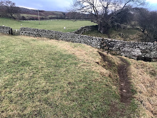
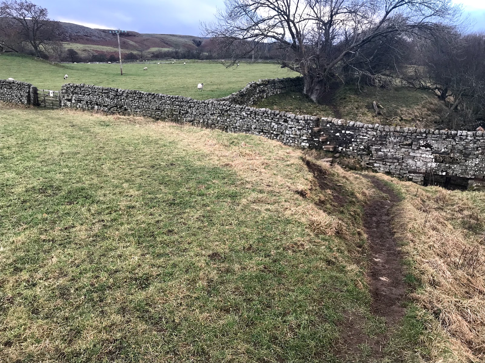
This can be described as wide runnable trail syndrome. Some how we will always choose a fast line over a smaller rougher track. We should be navigating navigating but in reality we get lazy.
The lucky few of you who have recce'd the course will have not had much trouble with the navigation. During a non stressed recce we tend not to overshot places where the PW branches off from a wide unable trail during daylight .
The lucky few of you who have recce'd the course will have not had much trouble with the navigation. During a non stressed recce we tend not to overshot places where the PW branches off from a wide unable trail during daylight .
When knackered in the dark without anyone else to follow we somehow miss these small side turnings especially when we are trucking along heading down hill. The classic place where this happens every January is where the Pennine Way joins the Pennine Bridal Way then branches off again.
SE018095 is the spot where several mental blips all conspire to send you the wrong way.
1 the PW Bridal way is wide ,firm ,downhill and in a sweeping curve to the left.
2 The PW itself is a small branch off to the right with the signage indistinct and off your eye line.
3 This will be around dusk or in the dark for most runners
4 You have just passed a road head which is usually marshaled (This interrupts your mental concentration)
5 Interacting with Marshals and other runners may have led to torchlight in the eyes ruining night vision.
6 Once interacting with marshals most of us tend to put in a spurt to regain lost seconds (we run off without thinking.
7 If one runner goes astray down the bridal way a whole bunch will follow.
8 The lead up to the road crossing is a slow section so straight after the road crossing we all tend to speed up.
THIS IS THE FATE OF AT LEAST 20 RUNNERS YEAR AFTER YEAR on Spine and Challenger.
You can make real speed downhill on the pennine bridal way for several Km and there is no big sign saying WRONG WAY The slog back up hill is a real bummer but at least you will have company of the other runners stalling in front of you who were drawn like moths by your head torch.
The Heard Effect
The attraction of the following or just sticking with a group, is overwhelming especially at night. Its not just that you cannot see that far but also that your body clock is telling you that you should be resting. Sight is our primary sense and we can mentally extend our sight by letting our brain latch onto the flicker of a head torch beam far ahead.
Some runners have rear facing flashing red LED's and these are particularly good at luring lagging runners to follow.
Another factor is the subliminal belief that any runner in front might be superior in ability and by default navigational ability.
Unless you actually know who the leading runner is and how good they are at navigating you should never assume they are going the right way
A lost or unsure leading runner will automatically seek reassurance by looking back . If a whole bunch of runners are still following then they will falsely take that as a sign that they are heading the right way.
A whole heard of runners heading the wrong way is difficult to halt. Even the last runner staring at a GPS showing the error will start to have self doubt.
The other problem with group running is that conversation is more fun than navigation. Unless one group member (Usually an Orienteer) takes charge the group will often blunder forwards without even thinking about navigating This is especially true of the high level parts of the course.
On low farmland groups are soon forced to get their act together.
Applying Psychology To Your Recce Trips.
We tend to move slower on a recce and so are less susceptible to navigational regression.
Most recce trips are done in daylight so our eyesight trail clues are stronger.
If you have never done the race you won't appreciate just how much harder it all is in race conditions.
You may be tempted to do more night recce's , and yes this will expose some of the potential nav traps but unfortunately you won't take in so many other memory sight information.
The ideal situation is that we visually memorise the whole course . In reality this is not possible even for someone with incredible visual memory capacity (It ain,t the same in the dark)
We need to recognise where we might make errors and try to memorise these locations
HIGH LEVEL AND FELL NAVIGATION
Nav errors on the high moors can easily loose you a Km . There are long periods where you are following a single track with no signs to tell you if you are heading the wrong way. PW signs will only be found at large path junctions and sometimes at fence/wall crossings The boundary crossings at high level can be several Km apart.
Many of the high level boggy areas have long lines of flagstones. However the primary function of the flagstones is to reduce erosion and not to indicate the Pennine Way. There are several junctions where the track branches and a fairly insignificant path will be paved while the Pennine Way branches off in a less erosion prone un paved direction.
Mental Approach
Start by making the assumption that you won't be looking at your map or GPS at all critical turns unless you are physically faced with a choice of left or right . T JUNCTIONS automatically force you to refer to your map/GPS
Y junctions are more tricky . if the wider non deviating path is correct you will probably be OK but if the PW is a less distinct track deviating from a larger path then you need to make a mental note and possibly mark your map and enter a pinging way point in your GPS.
Beware rail tracking . This is where you go for over 1km on one obvious trail. Somehow during the race your tired brain will get habituated to this trail and you will become more and more blinkered.
Typical example the CAM ROAD 3km before Haws . This junction has all the nav traps .
I The PW Deviates from a long wide track that you have been following for some hours.
2 The Actual PW is indistinct and sort of slides off to the right in the grass.
3 The finger post is set back from the Cam Road out of line of sight.
4 High altitude and probably foggy/dark
5 Exposed windy trail and you are probably distracted by the cold
6 The wrong direction( Cam Road) is down hill and inviting.
7 Its only 3k to the CP/finish line so Challengers are in full race mode and Spine racers are already tasting that CP hot food.
Every year 10% of night runners make this nav error and loose considerable time.
Every year 10% of night runners make this nav error and loose considerable time.
Pre any Recce get out the map and look at all the junctions that require course deviation. Go out there locate these points and ask yourself "Is there any way I can miss this path junction in the dark?"
LOW LEVEL FARMLAND NAVIGATION
Time is lost by multiple minor errors which once discovered give you the choice of retracing your steps or climbing Barber wire topped obstacles.
Time is lost by multiple minor errors which once discovered give you the choice of retracing your steps or climbing Barber wire topped obstacles.
This requires a different set of nav skills. Any recce of these areas should also be approached differently.
The main difference about the low level areas is that there are multiple paths ,junctions and farm animal trails.
As you are changing direction so often we tend not to fall into 'rail tracking' We are often faced with T junctions so the Map /GPS gets far more use . Your main issue will be trying to work out which muddy smear on the ground is the actual Pennine Way.
The biggest most well trod tracks are made by farm animals and none of them are in the race.
Things are made worse by the fact that many of the Pennine Way wall crossing points are often steps up walls (sometimes but not always with small wooden gates)
By definition they are stock proof so there will be no animal tracks to follow. The gates in themselves are difficult to spot in the dark and the steps up the walls are made of the same material as the wall . It is not unusual to completely miss a wall crossing when standing only 5mtrs away in the dark even with the aid of a good torch.

This wall crossing is typical of low level farm land . If you look closely you can see stone steps protruding from the wall like a ladder. In the dark the steps will be invisible unless you are side on to the wall. The only unusual feature is the sign post, most crossings are unmarked . Without that post you will have difficulty spotting wall crossings like this unless there is a well trampled track leading up to it.
The OS 1:50000 GPS base map does not show all the fence boundaries you will encounter. The same applies to the Harvies PW Maps which are fine on the high fells but don't have the detail required for fast night navigation in farmland.
AT night eyesight becomes more critical. PW trail makings are not on every fence crossing ,they are also small ,faded and don't show up well at night. Most are small faded yellow acorn symbols about 100 mm across.
The wooden finger posts are moss covered and difficult to read from a distance. If it snows the snow tends to stick to the wood completely obscuring the writing.
For low level fields the 1:25000 AZ maps are much easier to read but not being waterproof are easy to get damp and trash. You can put them in a plastic map case but you may need to take them out after 6Km in order to turn to the next page. The whole operation makes map work at low level a real chore so most of us rely on a best guess and the GPS map.
False Signs. (The Post Middleton Trail Trap)
There are places on the course where miss read/interpreted signs conspire to send you the wrong way.
One classic spot is about 500m past the Farm Auction Yard in Middleton. This is a point I raced passed 4 times racing in the Spine in the dark. Every time I came off trail and ended up climbing a wall. This was despite looking out for where I was going wrong . While volunteering in 2019 I got to look at this section in daylight and worked out where and how I went wrong.
To demonstrate how your mind can send you the wrong way I shall explain how my brain acted whilst racing .
Starting from the smelly auction yard you go through several gates heading parallel to the river on a wide track with a wall on your right side . It is significant that it was always in the dark. The track is level and firm and I would have been fed and rested and so pushing on quite fast. The right hand wall is fairly straight but up ahead is a small kink to the left where there is another gate with a white sign on it .

At this point the track peters out as seen above . The gate and sign are easy to spot in the head torch light . You will be drawn towards this gate .
Much larger GPS mapping errors frequently occur when the path on the ground deviates from that shown on the GPS map . The real track can often be 30 mtrs away from the mapped track in places.
For runners without a recce track you have to rely on zooming in and out of your base map image . Don't be alarmed if you are trudging along a path and your GPS is showing your position in the middle of a river running parallel and 5mtrs away from your position. This is all part of the challenge of the race. Navigation is all about taking in as many clues as possible and using your brain to sift out any erroneous data
By definition they are stock proof so there will be no animal tracks to follow. The gates in themselves are difficult to spot in the dark and the steps up the walls are made of the same material as the wall . It is not unusual to completely miss a wall crossing when standing only 5mtrs away in the dark even with the aid of a good torch.

This wall crossing is typical of low level farm land . If you look closely you can see stone steps protruding from the wall like a ladder. In the dark the steps will be invisible unless you are side on to the wall. The only unusual feature is the sign post, most crossings are unmarked . Without that post you will have difficulty spotting wall crossings like this unless there is a well trampled track leading up to it.
The OS 1:50000 GPS base map does not show all the fence boundaries you will encounter. The same applies to the Harvies PW Maps which are fine on the high fells but don't have the detail required for fast night navigation in farmland.
AT night eyesight becomes more critical. PW trail makings are not on every fence crossing ,they are also small ,faded and don't show up well at night. Most are small faded yellow acorn symbols about 100 mm across.
The wooden finger posts are moss covered and difficult to read from a distance. If it snows the snow tends to stick to the wood completely obscuring the writing.
For low level fields the 1:25000 AZ maps are much easier to read but not being waterproof are easy to get damp and trash. You can put them in a plastic map case but you may need to take them out after 6Km in order to turn to the next page. The whole operation makes map work at low level a real chore so most of us rely on a best guess and the GPS map.
False Signs. (The Post Middleton Trail Trap)
There are places on the course where miss read/interpreted signs conspire to send you the wrong way.
One classic spot is about 500m past the Farm Auction Yard in Middleton. This is a point I raced passed 4 times racing in the Spine in the dark. Every time I came off trail and ended up climbing a wall. This was despite looking out for where I was going wrong . While volunteering in 2019 I got to look at this section in daylight and worked out where and how I went wrong.
To demonstrate how your mind can send you the wrong way I shall explain how my brain acted whilst racing .
Starting from the smelly auction yard you go through several gates heading parallel to the river on a wide track with a wall on your right side . It is significant that it was always in the dark. The track is level and firm and I would have been fed and rested and so pushing on quite fast. The right hand wall is fairly straight but up ahead is a small kink to the left where there is another gate with a white sign on it .

At this point the track peters out as seen above . The gate and sign are easy to spot in the head torch light . You will be drawn towards this gate .
This is the same view but closer.
GPS MAPPING ERRORS
When you do a recce it is important to record your track then have your recce track displayed on the base map during the actual race. You will discover just how inaccurate GPS units can be . Errors of 5mtrs are not unusual and can be much worse in woodland areas. 5 mtrs may not seem much but at times you may have a choice of two gates to pass through . Choosing the wrong gate almost always puts you the wrong side of a high wall or fence and involve retracing your steps or climbing over barbed wire.Much larger GPS mapping errors frequently occur when the path on the ground deviates from that shown on the GPS map . The real track can often be 30 mtrs away from the mapped track in places.
For runners without a recce track you have to rely on zooming in and out of your base map image . Don't be alarmed if you are trudging along a path and your GPS is showing your position in the middle of a river running parallel and 5mtrs away from your position. This is all part of the challenge of the race. Navigation is all about taking in as many clues as possible and using your brain to sift out any erroneous data
GETTING FORCED OFF THE TRAIL
At times you may pass through flooded areas alongside rivers . The flooding can be extensive and cover any trace of the trail. We tend to walk around these areas as it is impossible to gauge their depth except by prodding with that invaluable walking pole . In avoiding floods we also tend to drop our guard and miss kinks in the trail. The approach to MALHAM is where this often occurs and many runners will get diverted up dead end field boundaries.
The same can happen if the ground is churned up by cattle . While trying to stay upright we we forget to look out for the trail.
Multiple racer footprints in snow or mud .
Just to mess with your head there are some small junctions on the course that regularly catch out racers. This can lead to a really clear wrong track as runners retracing their steps will double the number of footprints.
Tracks in snow are remarkably difficult to follow in the dark as your head torch will reduce the 3D effect .
Overseas Competitors And Folk Who Don't Have Recce Opportunity.
By studying the course with a Map and Google Satellite Image it is possible to actually deduce where you may make Nav Errors, especially on the high moorland areas . Look out for sharp changes in direction especially if they involve other wide tracks (as seen on the satellite image). You can insert Pinging Waypoints into some GPS devices just before the junctions to remind you to check your GPSThe low level areas are more difficult to analyse so during the race always check with other runners to see if they have done many daylight recce's before putting any trust into them.
Your best plan is to get into that habit of frequently checking your GPS. This refex action will start to make sense if you get in some orienteering practice. This will also help train your brain to relate your actual position to where you are on a map. The faster you can preform this mental function the more you will automatically actively navigate and the less mistakes you will make during the race.
In my next post I will take a detailed look at the trail between Airton and Pen y Gent including advice on negotiating Malham Cove in extreme conditions. This is one of the few sections of the course I have looked at while not racing . Racing over this section (always in the dark I know that I have made repeated nav errors as do most of the mid/tail end runners . Reading the post could save you one hr and several tears in your over trousers!
. Anyone covering this section in daylight will probably have very few problems and not have noticed the nav traps.
I'd be interested in your thoughts on Airton / Pen y Ghent as well as some guidance for the Malham Cove section. I've reccied it in good weather but still managed a minor nav issue on the Airton section.
ReplyDeleteThis section is covered in detail and published in 2018 . I agree it is one of the more complex nav sections especially as for most runners it is encountered in darkness. My notes on Malham cove in particular will help .
DeleteThis section is covered in detail and published in 2018 . I agree it is one of the more complex nav sections especially as for most runners it is encountered in darkness. My notes on Malham cove in particular will help .
Delete